In recent months there has been much talk of Azeri State Border Service (SBS) troops replacing Armed Forces troops at military positions along a segment of the Azerbaijan-Armenia border, precisely a segment near the cities of Qazakh and Agstafa. SBS troops came to man military positions in mid-December, leaving the traditional military forces free to be reassigned elsewhere. There is speculation that the Armed Forces troops stationed along the mentioned segment, allegedly part of the 707 Motarised Brigade, will now be transferred to areas along the line-of-contact between Nagorno Karabakh and Azerbaijan. Leaving these events aside, here we will outline one of the strategic points along the segment now manned by SBS troops.
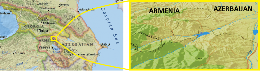
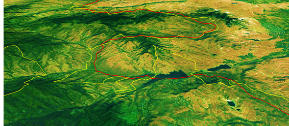
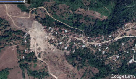
The area in question is the semi-enclave territory housing the villages of Quşçu Ayrım and Mezem. The area saw its share of armed combat in the early 1990’s, when improvised Azeri and Armenian irregular troops sought to protect their native villages, later replaced by regular army troops as both countries’ armed forces were formed. Although some casualties have been reported, no intense combat as that seen in the Nagorno Karabagh took place. Nonetheless, as seen on maps today, the real borders remain traced by a no-man’s land between the military border outposts of both sides, as opposed to the internationally recognised border between the two countries.
Over the semi-enclave towers a highly-militarised 1.230 metre hill (denominated Odundağ in Azeri or Paytasar in Armenian), which overlooks a clear 8 km to the west and northwest before the view is obstructed by higher mountains on the Armenian side of the border. To the south, visibility is even further, on clear days the Armenian town of Ijevan is visible a little more than 20 km away. The south of the semi-enclave is flanked by the Joghaz reservoir, a natural barrier against the movement of troops.
Odundağ (or Paytasar) Peak showing de iure and de facto boundries with distances
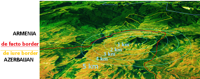
On the summit of Odundağ is a military outlook post, which also houses anti-air defence means according to some reports. In the case of armed conflict, this area would be vital for both sides. For Azerbaijan the mountain heights are important heights to observe Armenian troop movement, make us of an anti-air battery base and cut off one of the main roads running from the Georgian border to the Armenian capital Yerevan.
Armenian on the other hand, would highly benefit from the capture of this strategic point as it would essentially eliminate an important asset to the Azeri armed forces operating in the area (considering the three above mentioned factors). Besides the latter, Armenian troops would have a stable observation point overlooking dozens of kilometres of Azerbaijani territory in an area of the country (Azerbaijan) that is mainly a plateau.
The semi-enclave penetrates de iure 12 km in Armenian internationally-recognised territory, however as a result of fighting between the two sides, what really marks the border between these two countries are the military outposts. Although Azeris have an comparative advantage with Odundağ, the Armenians were able to push Azeri troops back and control a sizeable amount of the semi-enclave territory (although Azeri’s in this segment seem to have high ground).
Interestingly, de iure seems to find no place in the Caucasus, as the de facto situation on the ground continues to dictate what is really happening. Whether or not Azeri Border troops currently man Odundağ, it plays an important role in shaping the areas border-defence policy, be it for Armenia or Azerbaijan.


Comments are closed, but trackbacks and pingbacks are open.